


News from Jules | 09.17.2024 | DRT or Bust: Part 5
This is a sacred place.

Early that Tuesday morning in mid-August, I departed from my front door—just like the previous section of the Deschutes River Trail (DRT) that passes right through downtown Bend, Ore.—except this time on my bike since the trailhead was about 2.5 miles away.
We waffled about air quality down to the last minute and finally decided to go for it, even though the air quality index (AQI) was hovering over 100 which is unhealthy for sensitive folks, like those of us with asthma. Since mid-July—almost two weeks earlier than last year’s wildfire season—the air smelled like everyone in the neighborhood was having a lighter-fluid-soaked BBQ at the same time.
The air was hazy and the day was already heating up as I biked down my street for a couple of blocks, then turned down an alley to pick up my friend, coworker, and neighbor at her backdoor. From her house, we turned onto Portland Ave. and raced down the bike lane in the bright morning light until we turned left on First Street and arrived at First Street Rapids Park.
From there we retraced my dusty steps from the last DRT section past riverside homes, through the golf course, and back to Sawyer Park. After locking up our bikes, we set off by foot for the next five-mile section which wasn’t as much a trail as a wide gravel path that seemed designed more for bikes than feet. We slowly increased in elevation until we were on a ridge line high above the river and looking across a canyon lined with sprawling homes in every direction.
Even though there weren’t any fences, the scraggly high desert foliage, big boulders, and the iconic tall, red Ponderosa Pines of Central Oregon were clearly landscaped into someone’s yard.
After about a mile we were drawn toward some larger boulders on our right looking out across the river canyon and noticed how the houses abruptly stopped. I wondered if this was where the last section of the DRT picked up at Riley Ranch—which having never been I still thought was some kind of dude ranch.
At the 2.5-mile point, we just as abruptly walked up to a road with a gate and a small wooden marker that read: “End of the Deschutes River Trail.” Was this where the dotted line that I discovered this spring actually ended?
Instead of turning around, we veered left up a fairly steep gravel path through North Rim, a private community located on the northern face of Awbrey Butte featuring 121 one-acre homesites, and then back down an actual trail through the Archie Briggs Canyon Natural Area before popping out on the DRT.
Back on our bikes to race home, I had just enough time to grab lunch before heading to work. By the end of the day, I was exhausted. Looking at my iPhone Health app summary, I realized I had once again accidentally set a new Personal Record (PR). Between biking to the trail, hiking farther than anticipated, biking to work and walking around REI, it was an 18-mile day.
Two weeks later, my best friend was visiting from Denver over Labor Day weekend—the first time we’d been together since her wedding near Bend in October 2023.
We woke up bright and early, packed up our backpacks, and drove to the trailhead in northeast Bend about five miles from the duplex. It was our third hike in three days during our Bend staycation and I was excited to show her the DRT I’d been hiking all summer.
While we’d been lucky with good, clear air quality during her visit, the anticipated highs were in the 90°s Fahrenheit that Saturday so we planned to hike early, nap, and then float the river before dinner out in town.
Upon arrival, I quickly realized the Riley Ranch is not a dude ranch—though the land was still privately owned until 2015—but an 184-acre nature reserve, featuring 35 acres of canyon floor along the Deschutes River and a 30-acre band of rimrock cliffs according to Bend Park & Recreation.
The site was originally planned to be another subdivision with hundreds of homes just like we’d hiked through in the last section of the DRT; however, the development of a nature reserve instead was supported by a local land grant and opened in 2018.
The signs were very clear that dogs and bikes are not allowed, but humans are highly encouraged to hike and run on trail, which made it feel more like a park than a protected area of wilderness.
We set out on the trail through a grassy meadow to the mountain viewpoints before dropping down the rocky steps of a rimrock cliff to hike alongside the river. Down by the swirling clear water, the air was even more crisp and several degrees cooler than in the sun.
We passed the ruins of two log cabins, home to O.B. Riley, an 18-year-old pioneer on the Oregon Trail, originally from Ohio who passed through Portland before landing in Central Oregon. Three years after arriving in 1893, he and his mom were one of the earliest homestead settlers to claim a portion of the cheap land through the Donation Land Claim Act of 1850—which notably “discriminated against nonwhite settlers and had the effect of dispossessing land from Native Americans” according to Wikipedia—and later he did herd cattle there. He had a road named after him in 1904 and was now the namesake of Riley Ranch Nature Reserve, even though local news articles didn’t state a reason why other than that he lived there.
This portion of the trail down along the river and through the forest looked like the other wilder sections near Benham Falls, Dillon Falls, Big Eddy, and South Canyon, where the well-worn trail and few bits of litter seemed to be the only visible evidence of humans.
But, of course, we’ve affected this habitat so much more.
This was one of the many things we had talked about at length during her visit—the climate crisis, sustainability, rewilding, conscious consumption, and our own individual and collective actions including her start-up work in home electrification as one of the most significant ways to reduce carbon emissions.
Throughout the long weekend, we also caught up on life, our families, our friends, adventure plans and other stirrings of our souls while hiking, standup paddleboarding, floating, sitting at beer gardens, and strolling around town.
Our shared environmental values are a keystone of our relationship, plus we have so much fun together.
Soon we came upon a metal grated bridge high above the river—similar to the recently built one by Mirror Pond we hiked in the last section—that allowed us to wander past a rock wall and back into the forest before the trail entered Tumalo State Park. The forest quickly turned into a green grassy lawn Day Use Area with picnic tables beside the river, across the street from the large 100-site campground and a bridge across O.B. Riley Road.
Staying true to my initial inspiration, I wanted to follow the dotted line all the way to its end on the AllTrails map—and being one of my best friend’s she was willing to go along on the adventure even though that ended up extending our hike to about 9.75 miles.
We crossed the O.B. Riley bridge and continued along what seemed more like a narrow animal track through the reedy Cattails for about a mile or so before we arrived at a small and disappointing intersection with a few dusty tracks meandering onward, so essentially a dead-end unlike the small wooden marker on the west side of the river that clearly stated: “End of the Deschutes River Trail.”
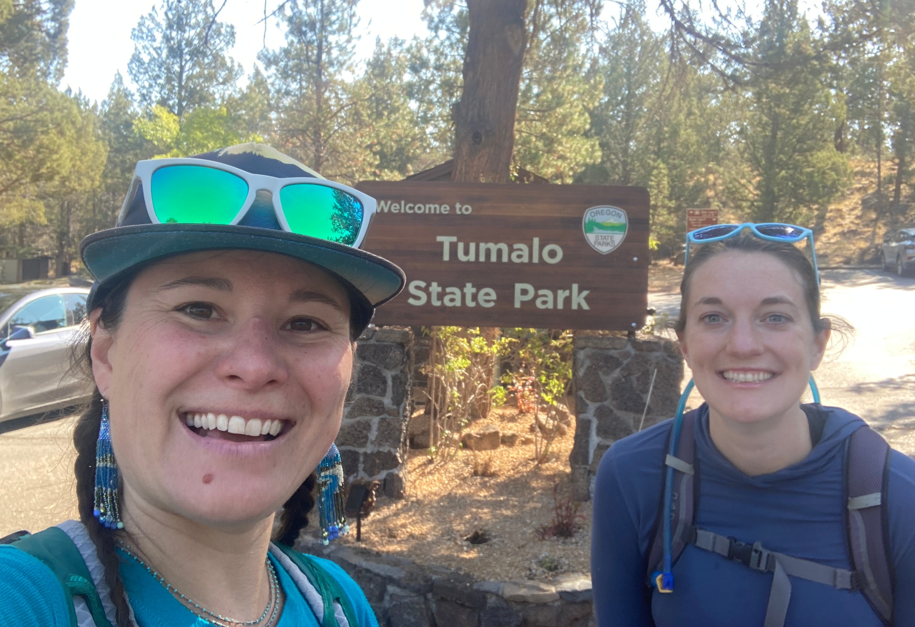
We concluded that our selfie in front of the Tumalo State Park sign near the campground would suffice as the actual end of the DRT. And thus, it was done!
See DRT photos from Sawyer Park to Tumalo State Park on Instagram.
I finished the 30-mile Deschutes River Trail, following the continuous dotted line alongside the Deschutes River from the north end of Sunriver through Bend to Tumalo State Park—well, 60 miles total since we hiked each of the 12 sections out-and-back—not just by my birthday, but on it!
Initially, it was just a wild idea for a “summer project,” wondering: What if I hiked all of that?
I didn’t know how far it was, how long it would take, when I’d go, or who would join me. I just knew Lindsey Scott’s sweet chant: “You don’t have to plan the way. Trust the way, feel your way. The Way knows, The Way knows the way.”
That dotted line took me through millions of years of dynamic geologic transformation; including thousands of years of volcanic activity that shaped the current path of the river that the Confederated Wana Łama (Warm Springs), Wasq'u (Wasco), and Northern Paiute tribes lived beside; and hundreds of years, well the past 200 years specifically, since settlers developed what we now know as Bend.
Now that I’ve seen it in sections, I’m eager to do the whole thing straight through end-to-end over a couple of days. To see the whole picture.
It took 16 weeks to complete 12 sections before work, after work, on weekdays and weekends, going solo several times, as well as hiking with 10 of my local friends—including one rockstar friend who hiked four sections with me!—plus my best friend from Denver, who flew in for my birthday weekend.
That wild idea grew into a commitment and the DRT project became a beautiful way to learn the river and get to know the land, spend quality time with new and old friends, plus strengthen my weakened right leg this summer. And a whole lot more.
It is clear how our relationship with the river now is so different from their relationship with the river—those who had lived here for centuries cohabitating with the plants, animals, rocks, water, earth and sky—and thus calling this place home.
How our relationships with each other are formed when there is more time and space to connect deeply in shared company and conversation—and yet how much easier it is to connect deeply with nature when one is solo.
How well one’s body heals steadily and gradually over time when we’re in a relationship with it—paying close attention and dedicated to repairing and rebuilding the strength to let’s say climb a mountain, literally or metaphorically.
The whole lot more is the spiritual stirrings I felt along the way as my spirit connected with all the other spirits around me. All summer I’ve wondered:
Is this river still wild? Or is it domesticated now?
Could it be both? Just like us as humans—wild in our hearts while also able to conform or adapt to the pressures around us.
According to interpretative signs I saw along the trail: “The unique geologic features of the Deschutes River helped solidify its addition to the National Wild and Scenic River System, which preserves rivers with outstanding natural, geological, cultural, and recreational values.”
My understanding is an intent to return the Deschutes River to its natural state—a beautiful, resilient, stable, and self-sufficient living being—through rewilding projects eventually, for instance removing dams or building fish ladders.
What if we also rewilded our relationship with this river, this land, this earth? And with ourselves?
I realized from the very beginning: This is not a place you visited once. This is a sacred place.
A place that I’ve now been, but that I’m just starting to know.
May you feel complete this week.
Love,
Jules
It's a beautiful end to your long journey along this river that also means so much to us! IT really is sacred in every way, unlike any river I lived close to. May all of its guests cherish and protect it!